Smoky Mountains NP TN
 |
| Rainbow Falls Trail |
The Great Smoky Mountains is the most visited national park in the USA and was acquired with donations from the public - which might explain why it has free entry. I’m not sure how they count the number of visitors though, as Yellowstone seems a lot busier to us. The temperate climate supports more tree species than Europe, 1,500 flowering plants, 200 species of birds and 60 species of animals including red fox, black bear, bobcat, turtles, white tailed deer, wild hog. The smell of the scented trees as we were walking up to Laurel Falls was exquisite. Everything is green because it rains a lot and we missed a torrential downpour by five minutes.
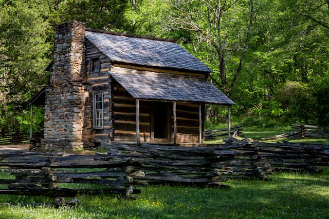 |
| John Oliver's Cabin |
We came in through Townsend and stayed in Cades Cove campground which is in the north west section of the park. There are a number of excellent brochures for motor trails, waterfall trails, hiking trails, wildflower trails and wildlife trails that you can purchase.
Cades Cove Loop
 |
| Cades Cove Loop Road |
Cades Cove Loop is an eleven mile one-way road that starts and ends not far from the campground entrance. There are numerous walks, a number of wooden churches, old cabins, old barns and the Abrams Falls which is at the end of a 2.4 mile trail. We weren’t prepared for a 3-4 hour moderate walk, so earmarked it for another day.
 |
| Inside the church |
 |
| Mill |
 |
| Primitive Baptist Church |
 |
| Cabin |
 |
| Methodist Church |
 |
| Carter Shields Cabin - it's like little house on the prairie |
Laurel Falls
Laurel Falls is a five mile return easy hike as it’s paved. It’s a pretty walk but personally I prefer natures ground to asphalt. It’s a nice waterfall and I managed to get a few pictures before people started climbing up the falls. Five minutes after we returned to our car it started raining and the temperature dropped by ten degrees, that was very good timing!
 |
| Laurel Falls |
The most beautiful and highest falls in the park are the Ramsey Cascades. It’s an eight mile return hike that increases by 2000’ over four miles. I really wanted to do it, so we made our lunch and some strong Gatorade. About 15 minutes down the road we realised that we’d left our water bottles on the kitchen bench and as we drove back the rain got heavier. Back out again when the rain had stopped.We stopped at the Sugarloaf Visitor Information centre to see how long the hike took as we were weren’t sure if we would have enough time now. It would be another half hour’s drive, a minimum of four hours for the hike, and more time for the photographs; a bit too long when it was nearly lunchtime. We decided to tackle Rainbow Falls.
There are times when I believe things happen for a reason, which will be evident later on.
Meigs Falls
Meigs Falls was on the way and can be seen from the Little River road, but is easy to miss as it is tucked away in the bushes We ended up using a zoom lens as it got a bit lost with my wide angle lens.
 |
| Meigs Falls |
Rainbow Falls
We got the last spot in the carpark. This is a delightful trail flanked by a plant that looks like a rhododendron, which isn’t but it must be magnificent when they are in flower. The buds are just forming so we are too early to see their magnificence. It’s a strenuous 5.4 mile return hike, all uphill to the falls, with lots of rocks, large and small to climb over or walk around. You have to keep your eye on the track. As it had been raining most of the night before, the track was wet and a bit spongy in places. There are a number of creek crossings and they get harder as you go on. As soon as we started the walk I knew I was in trouble as I had no energy, I had to stop every 10 minutes to catch my breath and have a drink. So lucky we hadn’t attempted Ramsey cascades. Only about a quarter of the way, I decided to eat half my sandwich and not long afterwards, I was feeling alive. It was like someone had flicked a switch, I’ve never experienced anything like it. Fuel was in the tank and I was ready to get to the top.
 |
| The first falls |
A log bridge takes you past the first smaller falls. There are two creek crossings after this point. The first one you need to jump across the rocks. The second one was nearly a deal breaker for me and I needed some encouragement. You have to jump about three feet from one sloping wet rock to another sloping wet rock with gushing icy cold water rushing through the middle. The reward? a 75’ waterfall. The Ramsey Cascades trail is longer and harder than the Rainbow Falls trail and as much as I want that picture, it would be stupid to attempt it.
 |
| Rainbow Falls |
 |
| More of Rainbow |
Roaring Fork Motor Nature Trail
We had a choice of going back the way we came or doing a loop down the Roaring Fork Motor Nature Trail, which takes you on a one way winding road back to Gatlinburg. The drive was a bit boring at first and we wished we hadn’t started it but as it’s one way, you have to keep going. The scenery wasn’t any different to any other road in the park. Then it started following the Roaring Fork Creek and the appeal greatly increased. There are a few cabins along the way but we didn’t stop at any of them as it was getting late. Lindsay had turned on our GPS and mobile and we seemed to have lost an hour. We stopped off in Gatlinburg to get fuel. This is where anyone who doesn’t camp in the park stays, I’ve never seen so many hotels and motels in one town. It seemed over the top touristy and I couldn’t wait to get out of there. I think the local claim to fame is moonshine. Are we in Hillbillies country?
 |
| Place of a thousand Drips |
On the way back to camp we stopped off at the sinks where the entire flow of the Little River goes. There were a number of whitewater kayaker’s coming through the rapids and down the river. It's not what I would call a waterfall.
Abrams Falls
 |
| Abrams Falls |
Abrams Falls trail is a five miles return moderate hike. A walk in the park compared to yesterday. The trail has a few small rocks to walk around or over but nothing like the Rainbow Falls trail. Most of it is on a moderate slope, except for a small section. Walking up hill is on the return leg.
 |
| Smoky or Yogi Bear? |
We had seen a small black bear off the track on the way up. On the return leg, he was on the track and a group of people had formed at each end. He didn’t seem to mind us too much. I don’t think we are on the menu here as there aren’t many animals for them to eat, so they are herbivores. After about 15 minutes he didn’t look like he was going anywhere soon, so we just walked right past him – about two feet between us. We’ve actually seen black bears every day here but haven’t bothered photographing them as the grass and bushes are too high.
Related Posts:
Great Smoky Mountains Part 2
Campground Review-1
Campground Review-2
American Australian
Counter Top Kitchen Bench
Weed chopper Brush cutter/Whipper Snipper
Smoky Smokey


Those trails are wonderful! Love all of the waterfalls and your beautiful photos. And the little bear, of course. It has been 30 years since I've been to the Smokies -- it's definitely in our plans in the next couple of years.
ReplyDeleteIt's a lovely park and I'm so glad we were there before May 15 - before the silly season
DeleteBeautiful capture of the falls! We enjoyed and explored the Great Smokies and glad you are having a great time there as well.
ReplyDeleteThank you Mona Lisa, I have to thank Lindsay for carrying my camera and tripod as I wouldn't have made it!
DeleteBeautiful capture of the falls! We enjoyed and explored the Great Smokies and glad you are having a great time there as well.
ReplyDelete