Island in the Sky
Canyonlands National Park, Utah
We moved north onto the other part of Canyonlands passing through Moab and picking up some groceries and fuel along the way. It rained most of the trip. |
| Mesa Arch |
Thousands of years ago, the Puebloans lived here, though any items or tools are long gone, newspaper rock shows some petroglyphs and some of their dwellings still remain.
 |
| Winter is back! |
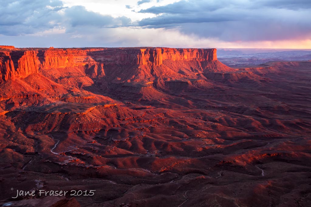 |
| These rocks only lit up for 5 minutes |
There was still fog as we went into the park the next day but it burnt off by about 11am. The views from The Green River overlook and Shafer Canyon are magnificent, this is what I expected Canyonlands to look like. We did a couple of walks to Wave Rock and Upheaval Dome Overlook which felt like they were longer than they were as they were uphill and we are at 6,000 feet.
 |
| Green River Overlook |
Our plans for shooting at sunset were shelved as the clouds rolled in and lightening spread across the sky, this is not a place you want to be out in when the weather is suspect. Then the sun came out, so we decided to go. We headed to the Green River Overlook that we had seen earlier on in the day, the closer we got the sun started to go behind the clouds but we kept on going anyway. At the overlook a photographer had been there during the storm which included hail and a wonderful rainbow but as he sensibly stayed in his car, he didn’t get any photos. Just before sunset, the sun shone through the bottom of the clouds. On the way home the storm resumed and we had a wonderful lightshow behind all the clouds. We saw one bolt of lightening so stopped to try and capture more, but all we got was rain!
We set our alarm for 5:30 the next morning. Lindsay got up to check outside and said it was very windy, so we decided to leave it until the next day as the forecast was for intermittent fog as well. Bed felt so lovely. Fifteen minutes later he says, com’on let’s go! It’s a half hour drive to the Mesa Arch and then a 15 min walk over sand and rocks to the arch. We got there in time but there were thirty other photographers there too! We nearly didn’t get a car spot nor did we get the best spot to take the photo. The iconic shot is when the sun lights up the underneath part of the arch which happens just after the sun has risen. You can also get some good shots as the sun rises and if you have your aperture set to above f/11 then you will get a star burst, but you can also get lens flare. After the sun was up I took my camera off the tripod to get some other composition
The following morning we were up before 5:30 and still there were many photographers already there. A few had very wide angle lenses and had selfishly positioned themselves very close to the arch which reduced the line as a whole, not allowing as many people to have the same opportunity.
 |
| Position position position |
Being here reminded me of a movie we saw a few years ago called 127 hours. A very fit young man came to Horseshoe Canyon in Canyonlands to ride his mountain bike and do a bit of hiking. Unfortunately for him he hadn’t told anyone where he was going. He liked to take risks, and he fell into a crevice and wedged his arm between two rocks. He had to endure rain, sun, heat and cold for five days before he decided that if he didn’t do something drastic, he would die. He amputated his arm with his pocket knife! He then had to get himself back to civilization, he was 30 miles from the nearest highway in a remote part of the park that not many people go to.
Related Posts:
Horsethief BLM Campground
South is the Needles section of Canyonlands National Park
In between the Needles and Island in the Sky sections of Canyonlands is Arches National Park
South of Needles is Monument Valley


Comments
Post a Comment